地图编号计算 |
您所在的位置:网站首页 › 军事地形图分幅与编号计算方法 › 地图编号计算 |
地图编号计算
|
主要内容
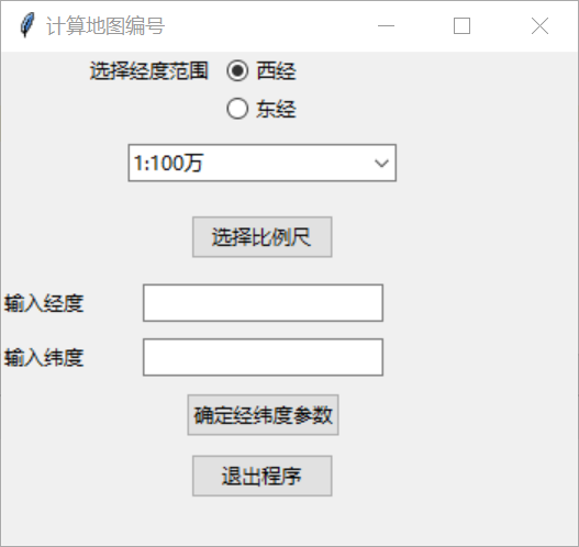
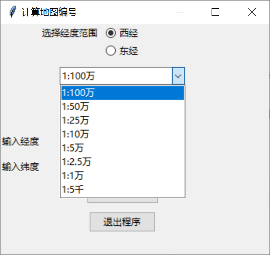
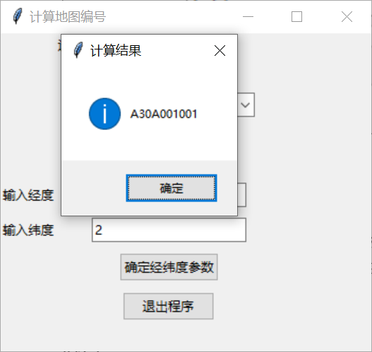
设计一个可视化界面,编写相应代码,实现的功能有:可以输入某一地方经纬度,选择比例尺,选择东、西经,计算该地的90年代后的分幅编号,并将结果显示。 设计思路主要包括input、scaleConvert、main三个文件。其中:input文件实现计算参数的输入与结果显示,scaleConvert文件实现不同比例尺下的参数转换,mian文件实现程序数据的计算。 代码实现 main.py文件 # 计算90年代后我国地形图的分幅编号 import math as ma # import input import scaleConvert as sC ''' x: 纬差 y: 经差 a:1比100万图幅所在纬度带的字符所 对应的数字码 b:1比100万图幅所在经度带的数字码 c:1比100万图幅编号后所在行号 d:1比100万图幅编号后所在列号 ''' # 计算1:100w以下比例的图幅编号 def minNumbering(lon, lat, scale, ew): x = sC.latitudeConvert(scale) y = sC.longitudeConvert(scale) a = ma.floor(lat / 4) + 1 be = ma.floor(lon / 6) + 31 bw = 30 - ma.floor(lon / 6) c = str(int((4 / x) - (ma.floor((lat % 4) / x)))) d = str(ma.floor((lon % 6) / y) + 1) c1 = c.zfill(3) d1 = d.zfill(3) ch1 = chr(ord(chr(a + 64))) ch2 = sC.scaleCodeConvert(scale) if ew == 2: return ch1 + str(be) + ch2 + str(c1) + str(d1) elif ew == 1: return ch1 + str(bw) + ch2 + str(c1) + str(d1) else: return "计算错误" # print("比例尺为:") # print(ch1 + str(b) + ch2 + str(c1) + str(d1)) # 获取经纬度 def main(): lat = eval(input("输入纬度:")) # 输入纬度 lon = eval(input("输入经度:")) # 输入经度 scale = input("输入比例尺:(100万,50万,10万,5万,2.5万,1万,5千)") # 输入比例 minNumbering(lon, lat, scale) return lat, lon, scale if __name__ == '__main__': main() scaleConvert.py文件 # 比例尺代码转换 def scaleCodeConvert(scale): numbers = { "1:100万": "A", "1:50万": "B", "1:25万": "C", "1:10万": "D", "1:5万": "E", "1:2.5万": "F", "1:1万": "G", "1:5千": "H" } return numbers.get(scale, None) # 经差转换 def longitudeConvert(scale): numbers = { "1:100万": 6, "1:50万": 3, "1:25万": 2/3, "1:10万": 1/2, "1:5万": 1/4, "1:2.5万": 1/8, "1:1万": 1/16, "1:5千": 1/32 } return numbers.get(scale, None) # 纬差转换 def latitudeConvert(scale): numbers = { "1:100万": 4, "1:50万": 2, "1:25万": 1, "1:10万": 1/2, "1:5万": 1/3, "1:2.5万": 1/6, "1:1万": 1/12, "1:5千": 1/24 } return numbers.get(scale, None) gui.py文件 from tkinter import * from tkinter.ttk import * from tkinter import messagebox import main def getSelection(): scale = var.get() ew = var1.get() n1 = eval(v.get()) n2 = eval(latitudeE.get()) messagebox.showinfo("计算结果", main.minNumbering(n2, n1, scale, ew)) root = Tk() root.title("计算地图编号") root.geometry("350x300+500+250") var1 = IntVar() var1.set(1) label = Label(root, text="选择经度范围", width=30) label.grid(row=0, column=1) choice1 = Radiobutton(root, text="西经", variable=var1, value=1, command=getSelection) choice1.grid(row=0, column=1) choice2 = Radiobutton(root, text="东经", variable=var1, value=2, command=getSelection) choice2.grid(row=1, column=1) v = StringVar() longitudeL = Label(root, text="输入经度") longitudeL.grid(row=6, column=0, pady=5) latitudeL = Label(root, text="输入纬度") latitudeL.grid(row=7, column=0, pady=5) longitudeE = Entry(root, textvariable=v) latitudeE = Entry(root) longitudeE.grid(row=6, column=1, pady=5) latitudeE.grid(row=7, column=1, pady=5) surebtn = Button(root, text="确定经纬度参数", command=getSelection) surebtn.grid(row=8, column=1, pady=5) exitbtn = Button(root, text="退出程序", command=root.destroy) exitbtn.grid(row=15, column=1, pady=5) var = StringVar() cb = Combobox(root, textvariable=var) cb["value"] = "1:100万", "1:50万", "1:25万", "1:10万", "1:5万", "1:2.5万", "1:1万", "1:5千" cb.current(0) cb.grid(row=3, column=1, pady=10) btn = Button(root, text="选择比例尺", command=getSelection) btn.grid(row=4, column=1, pady=10) root.mainloop() 运行结果
|
【本文地址】
今日新闻 |
推荐新闻 |