高德地图之周边搜索和路线规划 |
您所在的位置:网站首页 › 地图路径规划并获取坐标 › 高德地图之周边搜索和路线规划 |
高德地图之周边搜索和路线规划
|
前言: 当我们需要用到高德地图的时候,周边搜索和路线规划是常见的功能,我们也常常在旅游官网中见到他们的身影,因此接下来在Vue项目中来简单的演示一下这两个功能吧。 1.引入可以直接在public/index.html的头部添加,记住需要放到的前面。 //...其他代码 2.周边搜索1.在template里面添加div标签作为地图容器,同时为该div指定id属性。 2.设定地图的高度和宽度。 #Map { width: 650px; height: 350px; margin-top: 10px; }3.去高德申请key https://lbs.amap.com/api/webservice/guide/create-project/get-key 4.寻找官网周边搜索Api https://lbs.amap.com/api/webservice/guide/api/search
看下接口返回
很好,接下来就是把返回的信息展示出来。我曾经看到有一旅游官网里面的酒店详情页面,会将附近的景点坐标使用tab导航来展示,并且在地图上添加对应的marker坐标点,再给坐标点加上鼠标 Hover 事件。下面我们来实现一下。 html这里使用element的el-tabs,遍历pois,并且加上mouseover事件。 {{ item.name }} {{ (Math.round(item.distance) / 1000).toFixed(2) }}公里tab标签选项有风景、餐厅、停车场、酒店,当然也可以添加其他的label。 这里的label作为 searchAround(types)的参数。 data() { return { activeName: "scenery", pois: [], //周边搜索的数据 markers: [], //存储点标记 //自定义tabList数组 tabList: [ { label: "风景", name: "scenery" }, { label: "餐厅", name: "restaurant" }, { label: "停车场", name: "park" }, { label: "酒店", name: "hotel" }, ], }; }, // 生成点标记 setMarkers() { // 遍历 pois 列表, 让每个 poi 生成一个 marker this.markers = this.pois.map((poi, i) => { var marker = new AMap.Marker({ title: poi.name,//周边地点名称 position: poi.location.split(","),//周边地点坐标 content: `${i + 1}`,//标记覆盖物的内容 extData: poi.id,//将poi的id作为marker的id }); // 设置每个点标记鼠标Hover事件 // 传入当前的 poiId, 进行居中 marker.on("mouseover", () => { return this.showMarker(poi.id); }); return marker; }); // 使用通用函数,将整个地图的覆盖物清理掉 this.map.clearMap(); //添加点标记 this.map.add(this.markers); // 将地图的视图设为合适的大小 this.map.setFitView(); }, // 控制坐标点,找到需要居中的标记 showMarker(poiId) { // 外面传入 poiId this.markers.forEach((marker) => { // 判断标记的额外信息是否等于传进来的poiId // console.log(marker.getExtData()); if (marker.getExtData() == poiId) { // 将匹配点置顶(重叠的情况) marker.setTop(true); //显示一个提示窗 this.showTips(marker); // 设置地图以这个点居中 this.map.setCenter(marker.getPosition()); } }); }, // 居中时显示一个窗口 showTips(marker) { //显示一个提示窗 const infoWindow = new AMap.InfoWindow({ content: `${marker.getTitle()}`, offset: new AMap.Pixel(0, -32),//偏移量 }); infoWindow.open(this.map, marker.getPosition()); }, handleClick(tab, event) { //选中不同的标签页的时候把tab.label传到searchAround()函数调用接口。 this.searchAround(tab.label); },相关的css代码省略。 很好,接下来看看页面的效果。
我们先把单独的路线规划实现出来。 查看高德官网的API https://lbs.amap.com/api/webservice/guide/api/direction
看看效果:
很明显,如果采取起点到终点有点远,步行居然要12个小时。 当然,官网上还给出了其他的路线规划。
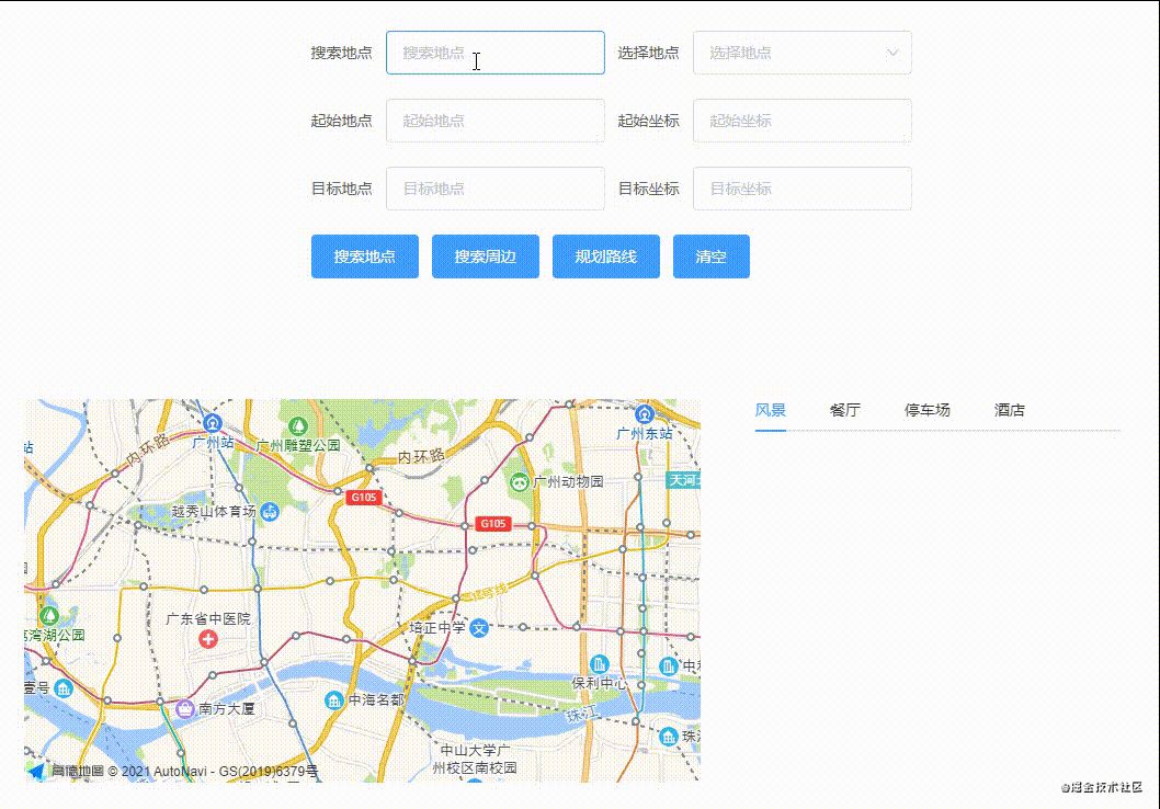
很好,时间缩短了。当然,也可以使用驾车路线规划,这里就不做演示。 4.功能合并为了功能更加完善,所以我们模仿平时使用高德地图的情景。 首先在输入框输入一个地址,比如学校。搜索,得到学校列表,选择其中一所学校。根据这所学校,以此为中心坐标,搜索周边景点。选择其中一处景点,规划学校到景点的路线。以下为全部代码: 搜索地点 搜索周边 规划路线 清空 {{ item.name }} {{ (Math.round(item.distance) / 1000).toFixed(2) }}公里 import { axiosMap, baseUrl } from "@/request/axios.js"; export default { data() { return { activeName: "scenery", pois: [], //周边搜索的数据 markers: [], //存储点标记 map: null, //生成的地图 tips: [], //搜索的地址列表 tabList: [ { label: "风景", name: "scenery" }, { label: "餐厅", name: "restaurant" }, { label: "停车场", name: "park" }, { label: "酒店", name: "hotel" }, ], form: { location: "", //搜索地点 chooseLocation: null, //搜索地点坐标 coordinate: "", //起始地点 origin: "", //起始地点 targetCoordinate: "", //目标坐标 targetLocation: "", //目标地点 }, }; }, mounted() { // 创建地图 this.createMap(); }, methods: { //选择初始坐标 changeLocation(val) { this.form.origin = val.name; //起始地点 this.form.coordinate = val.location; //起始坐标 // 使用通用函数,将整个地图的覆盖物清理掉 this.map.clearMap(); let marker = new AMap.Marker({ title: val.name, //地点名称 position: val.location.split(","), //地点坐标 content: `${val.name}`, //标记覆盖物的内容 }); //添加点标记 this.map.add(marker); // 设置地图以这个点居中 this.map.setCenter(val.location.split(",")); // 将地图的视图设为合适的大小 this.map.setFitView(); }, //选择景点 choosePoi(item) { this.form.targetLocation = item.name; //目标地点 this.form.targetCoordinate = item.location; //目标坐标 }, //创建地图 createMap() { this.map = new AMap.Map("Map", { zoom: 13, }); }, //根据type生成标记或路线 setMap(type) { //根据type显示不同地图 if (type == "Marker") { //遍历 pois 列表, 每个地点都创建一个 marker 放到地图上 this.setMarkers(); } else if (type == "panel") { //规划步行路线 this.setWarking(); } }, //搜索地点 searchLocation() { let data = { key: "您申请的key值", location: "113.40135612,23.0855435", //以此坐标搜索周边 keywords: this.form.location, //关键字 }; axiosMap("v3/assistant/inputtips", "get", data).then((res) => { this.tips = res.data.tips; //将请求所得的标记储存起来 }); }, // 周边搜索 searchAround(types) { let data = { key: "您申请的key值", location: this.form.chooseLocation.location, //以此坐标搜索周边 types, //默认为风景 }; axiosMap("v3/place/around", "get", data).then((res) => { this.pois = res.data.pois; //将请求所得的标记储存起来 //生成标记 this.setMap("Marker"); }); }, setWarking() { //步行导航 var walking = new AMap.Walking({ map: this.map, panel: "panel", }); //根据起终点坐标规划步行路线 walking.search( this.form.coordinate.split(","), //起点和终点坐标为数组 this.form.targetCoordinate.split(","), (status, result) => { console.log(status, result); // result即是对应的步行路线数据信息,相关数据结构文档请参考 https://lbs.amap.com/api/javascript-api/reference/route-search#m_WalkingResult if (status === "complete") { // log.success("绘制步行路线完成"); } else { // log.error("步行路线数据查询失败" + result); } } ); }, //路线规划 pathPlanning() { let data = { key: "您申请的key值", origin: this.form.coordinate, //出发点 destination: this.form.targetCoordinate, //目标点 }; axiosMap("v3/direction/walking", "get", data).then((res) => { // 使用通用函数,将整个地图的覆盖物清理掉 this.map.clearMap(); //生成路线 this.setMap("panel"); }); }, // 生成点标记 setMarkers() { // 遍历 pois 列表, 让每个 poi 生成一个 marker this.markers = this.pois.map((poi, i) => { var marker = new AMap.Marker({ title: poi.name, //周边地点名称 position: poi.location.split(","), //周边地点坐标 content: `${i + 1}`, //标记覆盖物的内容 extData: poi.id, //将poi的id作为marker的id }); // 设置每个点标记鼠标Hover事件 // 传入当前的 poiId, 进行居中 marker.on("mouseover", () => { return this.showMarker(poi.id); }); return marker; }); // 使用通用函数,将整个地图的覆盖物清理掉 this.map.clearMap(); //添加点标记 this.map.add(this.markers); // 将地图的视图设为合适的大小 this.map.setFitView(); }, // 控制坐标点,找到需要居中的标记 showMarker(poiId) { // 外面传入 poiId this.markers.forEach((marker) => { // 判断标记的额外信息是否等于传进来的poiId // console.log(marker.getExtData()); if (marker.getExtData() == poiId) { // 将匹配点置顶(重叠的情况) marker.setTop(true); //显示一个提示窗 this.showTips(marker); // 设置地图以这个点居中 this.map.setCenter(marker.getPosition()); } }); }, // 居中时显示一个窗口 showTips(marker) { //显示一个提示窗 const infoWindow = new AMap.InfoWindow({ content: `${marker.getTitle()}`, offset: new AMap.Pixel(0, -32), //偏移量 }); infoWindow.open(this.map, marker.getPosition()); }, handleClick(tab, event) { //选中不同的标签页的时候把tab.label传到searchAround()函数调用接口。 this.searchAround(tab.label); }, //清空数据 clearData() { this.form = { location: "", //搜索地点 chooseLocation: null, //搜索地点坐标 coordinate: "", //起始地点 origin: "", //起始地点 targetCoordinate: "", //目标坐标 targetLocation: "", //目标地点 }; this.pois = []; //周边搜索的数据 this.tips = []; //搜索的地址列表 }, }, };样式代码就不展示了,虽然页面简陋,但是研究起来还是蛮有意思的。最后展示一下效果图。
|
 封装一个简单的axios文件,新建src/request/axios.js文件。
 好了,周边搜索效果已经出来,那么我们能不能再原有的基础上,使两个不同的景点像导航那样把路线画出来。接下来就要用到高德地图的路线规划。


 原文地址:https://juejin.cn/post/6982881752423350308
【本文地址】
今日新闻 |
推荐新闻 |