GIS二次开发:实验一 ArcGIS Engine 开发初步 |
您所在的位置:网站首页 › GIS二次开发现状 › GIS二次开发:实验一 ArcGIS Engine 开发初步 |
GIS二次开发:实验一 ArcGIS Engine 开发初步
|
实验一 ArcGIS Engine 开发初步
一、实验目的
掌握ArcGIS Engine的安装;熟悉ArcGIS Engine中几个常用的控件;搭建第一个简单的ArcGIS Engine 程序;通过ICommand接口添加地图浏览工具。
二、实验仪器与设备
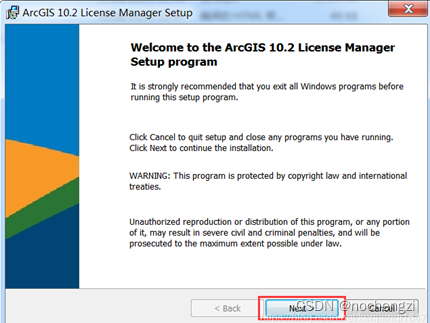
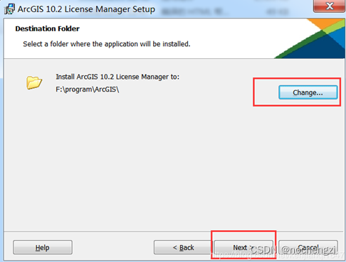
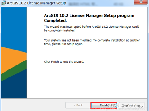
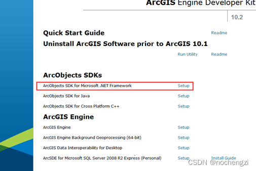
计算机、visual studio 软件、ArcGIS engine 开发包 三、实验内容与步骤 ArcGIS engine安装及环境配置。 (1)安装ArcGIS License Manager
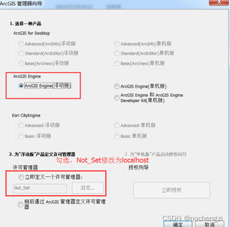
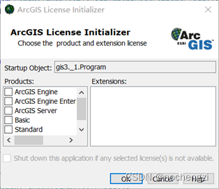
(2)安装ArcGIS Engine 10.2,选择以下路径中的ESRI.exe 点击安装: (3)打开ArcGIS管理器导向,选择ArcGIS Engine浮动: 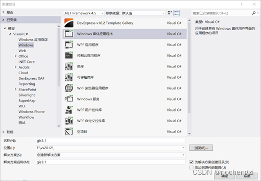
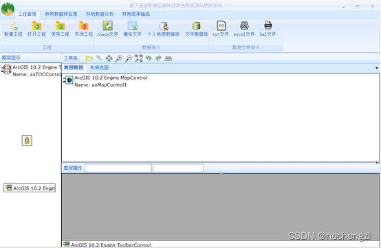
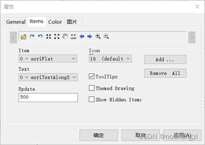
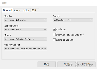
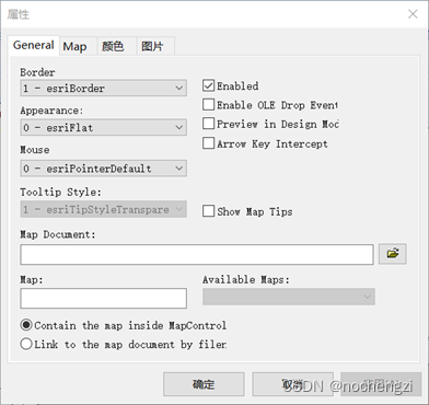
(2)选择需要添加的ArcGIS引用项,在【License Checking】选项页中选择需要的软件许可授权和扩展模块许可授权。 (3)在【工具箱】面板中找到【ArcGIS Windows Forms】选项卡,此选项卡中包含有ArcGIS Engine中所有的可视化控件,选择需要的控件添加到【gis3.1】窗体中。 (4)添加地图浏览工具,打开工具条属性,执行以下操作。 (5)选中TOCControl控件,单击鼠标右键,选择【属性】,弹出对话框,在【General】选项卡的“Buddy”下拉列表中选择与其绑定的MapControl地图控件,这样当程序运行时TOCControl控件才可以与地图控件进行联动。 (6)选中MapControl控件,单击鼠标右键,选择【属性】,弹出对话框,在对话框中选择程序运行时加载的*.mxd地图文档,点击【确定】按钮完成对*.mxd文档的关联。 
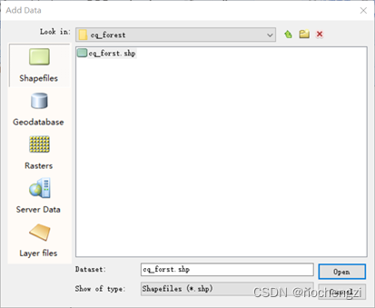
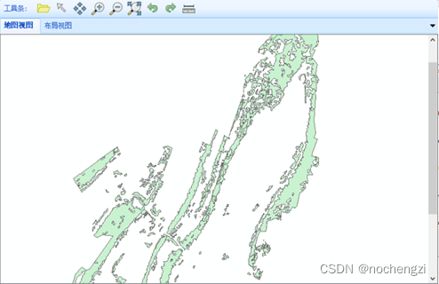
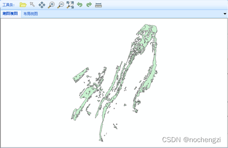
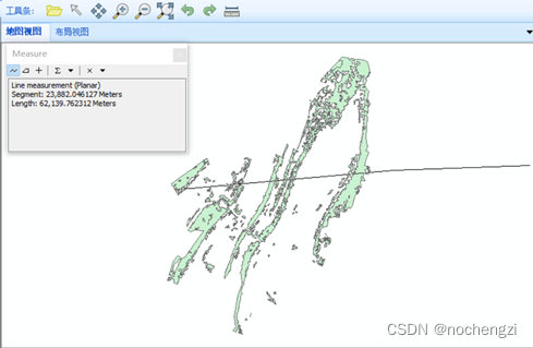
(2)分别实现对应按钮的事件响应代码: /// /// 工具条 /// /// /// /// 打开文件夹 private void buttonI_opendata_Click(object sender, EventArgs e) { ICommand pcommand = new ControlsAddDataCommandClass(); pcommand.OnCreate(axMapControl1.Object); pcommand.OnClick(); updatalayernametoconbox(); } /// /// 默认鼠标 /// /// /// private void buttonI_default_Click(object sender, EventArgs e) { if (m_ControlsSynchronizer.ActiveViewType == "MapControl") { axMapControl1.CurrentTool = null; axMapControl1.MousePointer = esriControlsMousePointer.esriPointerDefault; } else { axPageLayoutControl1.CurrentTool = null; axPageLayoutControl1.MousePointer = esriControlsMousePointer.esriPointerDefault; } } /// /// 漫游 /// /// /// private void buttonI_pan_Click(object sender, EventArgs e) { if (m_ControlsSynchronizer.ActiveViewType == "MapControl") { ICommand pcommand = new ControlsMapPanToolClass(); pcommand.OnCreate(axMapControl1.Object); axMapControl1.CurrentTool = pcommand as ITool; } else { ICommand pcommand = new ControlsMapPanToolClass(); pcommand.OnCreate(axPageLayoutControl1.Object); axPageLayoutControl1.CurrentTool = pcommand as ITool; } } /// /// 放大 /// /// /// private void buttonI_zoomin_Click(object sender, EventArgs e) { if (m_ControlsSynchronizer.ActiveViewType == "MapControl") { ICommand pcommand = new ControlsMapZoomInToolClass(); pcommand.OnCreate(axMapControl1.Object); axMapControl1.CurrentTool = pcommand as ITool; } else { ICommand pcommand = new ControlsMapZoomInToolClass(); pcommand.OnCreate(axPageLayoutControl1.Object); axPageLayoutControl1.CurrentTool = pcommand as ITool; } } /// /// 缩小 /// /// /// private void buttonI_zoomout_Click(object sender, EventArgs e) { if (m_ControlsSynchronizer.ActiveViewType == "MapControl") { ICommand pcommand = new ControlsMapZoomOutToolClass(); pcommand.OnCreate(axMapControl1.Object); axMapControl1.CurrentTool = pcommand as ITool; } else { ICommand pcommand = new ControlsMapZoomOutToolClass(); pcommand.OnCreate(axPageLayoutControl1.Object); axPageLayoutControl1.CurrentTool = pcommand as ITool; } } /// /// 全局 /// /// /// private void buttonI_fullscreen_Click(object sender, EventArgs e) { ICommand pcommand = new ControlsMapFullExtentCommandClass(); pcommand.OnCreate(axMapControl1.Object); pcommand.OnClick(); } /// /// 前一视图 /// /// /// private void buttonI_preview_Click(object sender, EventArgs e) { if (m_ControlsSynchronizer.ActiveViewType == "MapControl") { ICommand pcommand = new ControlsMapZoomToLastExtentForwardCommandClass(); pcommand.OnCreate(axMapControl1.Object); pcommand.OnClick(); } else { ICommand pcommand = new ControlsMapZoomToLastExtentForwardCommandClass(); pcommand.OnCreate(axPageLayoutControl1.Object); pcommand.OnClick(); } } /// /// 后一视图 /// /// /// private void buttonI_aftview_Click(object sender, EventArgs e) { if (m_ControlsSynchronizer.ActiveViewType == "MapControl") { ICommand pcommand = new ControlsMapZoomToLastExtentBackCommandClass(); pcommand.OnCreate(axMapControl1.Object); pcommand.OnClick(); } else { ICommand pcommand = new ControlsMapZoomToLastExtentBackCommandClass(); pcommand.OnCreate(axPageLayoutControl1.Object); pcommand.OnClick(); } } /// /// 测量 /// /// /// private void buttonI_measure_Click(object sender, EventArgs e) { ICommand pcommand = new ControlsMapMeasureToolClass(); pcommand.OnCreate(axMapControl1.Object); axMapControl1.CurrentTool = pcommand as ITool; } /// /// 鼠标移动显示坐标 /// /// /// private void axMapControl1_OnMouseMove(object sender, ESRI.ArcGIS.Controls.IMapControlEvents2_OnMouseMoveEvent e) { toolStripStatusLabel2.Text = "x=" + e.mapX.ToString() + ",y=" + e.mapY.ToString(); if (axMapControl1.LayerCount != 0) { //ShowTips显示的要素类 IFeatureLayer pFeatureLayer = axMapControl1.Map.get_Layer(0) as IFeatureLayer; if (pFeatureLayer is IFeatureLayer) { pFeatureLayer.DisplayField = "DDMM"; //ShowTips显示的字段名称 //pFeatureLayer.DisplayField = "Shape"; //pFeatureLayer.DisplayField = "OBJECTID"; //pFeatureLayer.DisplayField = "Shape_Leng"; //pFeatureLayer.DisplayField = "Shape_Area"; //将两个ShowTips属性设置为true pFeatureLayer.ShowTips = true; axMapControl1.ShowMapTips = true; } } }四、实验结果 1.文件加载 2.放大 3.缩小 4.全局 5.测量 1.学会了在Visual Studio中安装部署ArcGIS engine,并且使用ArcGIS控件创建一个小程序。 2.学会了使用ArcGIS控件创建一个工具条,以及自己创建一个工具条两种方法。 3.对ArcGIS engine的理解进一步加深。 |

【本文地址】
今日新闻 |
推荐新闻 |